Wednesday, September 30, 2020

My Journey to Learn about the True Promised Land


Over the past ten years, I have been led on a journey which took me totally by surprise.  This journey strengthened my testimony of the Book of Mormon more than anything else in the world. I have read and studied this book from cover to cover countless times from 1981 to present day, and I know without a shadow of a doubt that it is “Another testament of Jesus Christ. What took me a step further in my testimony was the journey as to where the Book of Mormon lands are located. 

A view of the Nauvoo Temple from Zarahemla

2005: Fifteen years ago, my two oldest daughters attended college in Alabama: one at Auburn University and the other in Montgomery, Alabama (Huntington College). Many times we would drive up to visit them there which took 3 to 3 ½ hours each way. Driving back and forth presented a lot of time to think and ponder. Sometimes the Spirit would impress upon my mind interesting information. One of those being about some of the early people who lived in Alabama before the Europeans arrived.  I would see in my mind men running with girded loins and bare chests in and out of the wooded areas as I drove by.  I never really thought much of it until later on.

2014: During this year I started finding and watching some videos about the Heartland Model talking about Promised Land from The Book of Mormon being in the United States. This was an interesting idea as all I’ve heard was that the Book of Mormon lands were in Central America.  I never understood all of that information and it was confusing to me especially with the idea of having two Hill Cumorahs.  How can there be two Hill Cumorahs? There is no way to me that Moroni could drag all of those plates, sword of Laban and the Liahona from Central America to New York State. There must be more to all of this.

2015: With several weddings to attend in Utah, my family and I stumbled on a conference at the UVU Conference Center in Orem in April which promoted the Heartland Model. I know that nothing happens by accident and as I attended the conference I felt that I was being taught some Book of Mormon truths. After pondering the Heartland Model for ten years I felt that I really knew the people of the Book of Mormon and where they lived. I bought and read an interesting book called Prophesies and Promises by Bruce H. Porter and Rod Meldrum which explained the whole Heartland Model in a very simple and easy to understand manner.

May 2020: After finding the Zarahemla site on Facebook, I contacted the site manager and asked if they were in need of volunteers to help with their expedition in August of 2020. We were planning a trip back east anyway, but had not made final plans. I was overjoyed to find that my services would be greatly appreciated and planned to meet this group in August in Nauvoo to help with writing their blog.

August 2020: My experience in Nauvoo, Illinois and Montrose, Iowa was a highlight of my life. The Lord was with us the whole way and we were able to learn about some of the point places of the Book of Mormon:

·         Both the families of Lehi and Mulek crossed the Atlantic Ocean

·         The place of Lehi’s Landing is Florida, near Pensacola.

·         The place of Mulek’s Landing is the Great Lakes Area

·         The Land of Nephi covers all the Tennessee and surrounding areas.

·         The River Sidon is the Mississippi River

·         The battle fought in Alma 2 between Amlici and Alma  was near Montrose Iowa and Nauvoo Illinois.

·         The Land of Zarahemla stretched from Nauvoo, Illinois to Montrose Iowa.

·         The Hopewell culture in the United States are the Book Of Mormon Nephites

·         The only Hill Cumorah is in New York State

·         The early Native American people living in the East, came from the East.

·         The United States of America is the Promised Land of the Book of Mormon

 Through these spiritual experiences and visiting areas on the Eastern side of the United States, my testimony of the Book of Mormon has been strengthened tenfold. I am learning more every time we study and read. I know the United States is the covenant Promised Land the Lord has guided the people of Jared, Lehi’s family and Mulek, the son of Zedekiah to live.  It is our beautiful United States and we should recognize how blessed we are to live in the Promised Land.

Riding the Mississippi River

 Our third day on the Expedition (August 5th) was spent on the Mississippi River.  We were with our Heartland Research Group on the boat “Truth” along with sonar equipment (using a sound ping sent to the bottom and coming back as a picture) expert Don Cummings. He was onboard to take more pictures of the bottom of the river.  

This time we had Don Blum and his diver brother and cousin with us. We were hoping for a human eye’s view from our two divers exploring the river bottom near where the crossing could have occurred over 2,000 years ago. This crossing is recorded in Alma chapter 2 in the Book of Mormon during the war between the Lamanites and Nephites. Finding this crossing would connect the ancient account to the geography on digital maps.


Two thousand years ago, even 200 years ago, the Mississippi River was crossable by foot at the harvest time of the year. Sitting on that boat it was hard to believe anyone could cross by foot but we tried to visualize what could have happened from our vantage point.   Before the Keokuk Dam was built in 1913, the rapids on the Mississippi River (called the Des Moines Rapids) were 12 miles long but only three feet deep. Since 1913, the river had risen 18 feet and that area of the Keokuk bend was difficult to imagine anyone crossing by foot. Gone are the little islands shown on a late 1800 map. Gone are the areas which could have been crossed so long ago.

 From the boat outing the day before, Don Cummings along with Mike Baker found three key areas where this crossing could have occurred. The first is called Sandusky and with the sonar scans, it was the most likely place for our divers to explore. The nature of the limestone as a horizontal ledge at the Keokuk Gorge at Sandusky would have been much shallower before the dam was built.


We also had Don Blum with us who has over 40 years experience as an explosive expert for a good part of the Mississippi River.  Before he even got on the boat he talked about the dangers of diving down into the Mississippi.  According to many divers, the Mississippi river is the most dangerous body of water to scuba dive into. It’s murky with very limited visibility and has whirlpools that catch divers who can lose their sense of direction. Then there are the leftover grappling hooks from past fishing excursions which can grab onto arms or legs and not let go. There are also many large logs which are hard to see with 150 pound catfish, snapping turtles and snakes swimming around, all creating a most dangerous place to dive.

Then we learned about Don’s experience blasting rock on the Mississippi River and how the Keokuk Gorge area, which have layers of limestone and is one of the hardest rocks ever blasted in his 39 years of blasting. Once blasted into pieces, these boulders called “riprap” are used to protect the banks of many rivers from erosion. From the Missouri River to the Moline River in Illinois to the end of the Mississippi river in New Orleans, barges of riprap are sent down the river to be used as protection from disintegrating river banks.


Our time on the river was an adventure as the wind blew and the waves pushed against the boat. It was time for the divers to go down to see if they could find that limestone ridge. Once in the water, the visibility under the water was just too difficult to see anything.  Even with underwater headlights, it was too dangerous to go any farther.  It was a great disappointment to us all, but there was nothing we could do.

With this experience now behind us, our divers will get another chance to go again in the future. Using 3D sonar and more powerful lights, the chances will be better to pinpoint a location to search and find the original banks of the river.  We will find better visibility and another time of the year would be better with little waves and no wind.  We will look forward to another excursion to ride down the Mississippi River and find the ancient crossing.

Mounds of History

 If you have ever traveled the eastern side of the country from Alabama to Michigan, you might have seen large areas of fields or woods that have mounds of dirt covered with grass that stand over 15 feet high. Some are not that high, but smaller mounds in wooded areas.  If you have been lucky enough to find these cherished burial grounds of an ancient people, you should call yourself very blessed.


  There are some places on earth that are so sacred, you cannot take a picture of it nor tell others of your experience.  They don’t fully understand what you have felt and many times make fun of what they don’t understand. Our visit to the Nauvoo Ancient Mounds on Tuesday’s (August 5th) excursion was a sacred one. It was life changing.


Walking along these burial grounds, one can feel a sacredness not matched in most places. Two thousand years ago the early ancestors of today’s Native Americans lived there along the banks of the Mississippi River. Roaming around these mounds, gives most people a feeling of serenity and peacefulness. It is believed that these mounds are a part of the Hopewell culture of 550 BC to 400 AD and are like “grave stone marker” that we would use today. Some believe this ancient mound area is the famous Hill Amnihu from The Book of Mormon’s Alma, Chapter 2.  I’m one of those believers.


When the care takers, Jennice and Wilson Curlee first started to clean up the area of the Nauvoo Ancient Mounds, it was discovered that some of the mounds had been looted and disrupted, leaving the mound partially open. There is a special ceremony to restore these mounds and the Curlees were able to organize enough people to replace these open mounds.


 First, the mound was cleaned for the dirt to be filled. A special material is laid in the spot for the soil. Then soil is brought by dump truck and piled close by to use for the fill. Then bucket by bucket in a bucket brigade, people placed the soil to recover the mound.


With much study and research, this special place along the Mississippi River was discovered to have many burial mounds. The early pioneer Saints of 1839, who settled there, leveled some of those mounds without knowing who was buried there before their arrival. There are many more mounds which have been discovered on the hill top of the Nauvoo Ancient Mounds since then and are kept safe with cemetery status from the State of Illinois.

Close to the Mississippi river where they laid Joseph and Hyrum Smith’s body along with their parents and Emma Smith, was discovered a Nephite burial ground. There are mound sights all along the Mississippi river on the Illinois side in Albany, East Dubuque at Granmercy Park and at the Little Maquoketa River Mounds State Preserve.


 There is one special burial mound which was discovered back in 1834. During the months of May and June of 1834 Joseph Smith led more than 200 men on a trek called Zion’s Camp from Kirtland, Ohio to Clay County, Missouri. It was an unsuccessful attempt to regain land from which the early members of The Church of Jesus Christ of Latter-day Saints were expelled by non-member settlers. It was on June 3rd while passing through west-central Illinois

 near Griggsville, that some bones were uncovered from a mound.  Through personal revelation and inspiration, Joseph Smith identified these bones belonging to a white Lamanite and chieftain-warrior named Zelph. It was also told that he was a “thick set man of God”. There was a sharp arrowhead stuck in his side near his ribs. According to the story, one of his thigh bones was broken apparently by a stone flung from a sling while in battle years before his death. He was killed in the battle during the last great struggle of the Lamanites and Nephites.

There is so much history living in these mounds. Peoples’ lives were lived with families in times of peace and in war. There is so much we don’t know about those who lived so long ago, but we can revere these burial grounds. One day we will meet those who lived in this area and they will have wonderful stories to tell.

The Curlees continue to treat the mounds with reverence and hope to preserve the entire site of the hill for the future.  They believe that this ridge or hill outside of Nauvoo is the ancient Hill Amnihu as mentioned in Alma chapter 2, and that the mounds and ancient fortification are located on that hill. Visitors are welcome to walk through the land and see the mounds located about 2 miles north of Nauvoo on Sycamore Haven Drive and feel for yourself about this sacred place.

 Nauvoo Mounds

Thursday, August 13, 2020

The Expedition Begins....


Have you ever thought about those family members who have gone on before you were born? You’ve never seen a picture of them but you are sure they exist from the stories told about them. Then you find evidences of these family members, like pictures or letters they wrote and you know for sure that they exist.  Knowing this gives you great comfort.

It’s the same with Zarahemla.  Zarahemla is the largest, ancient city of the Nephite nation written about in The Book of Mormon. We know it exists as we read about it in the Book of Mormon, but where is it?  Monday, August 3rd, was the first day of the Heartland Research Group’s expedition to find the river crossing from Alma Chapter 2 which will point us in the right direction in finding the city of Zarahemla.

The Heartland Research Group is made up of a group of very special people. John Lefgren, the organizer, one of the main thrust of the group, our quarterback you might say, educated in economic history, keeps us on task to accomplish our goals. Then there is Wayne May who is an authority on ancient North American archaeology, publisher of Ancient American Magazine who manages the 14-acre site where the ancient Nephite temple lot sits.

Jeff Green is next and he owns and is the captain of the pontoon boat “Truth” getting us out there on the Mississippi River. Kevin Price is onboard as our leading scientist in imaging, remote sensing and geographic information as well as many years in botany study. Dave Holmes came aboard as our investigative reporter, digging up as much information as he could. Don Cummings came with his sonar scanner equipment which was a big part of finding this crossing as he could take sonar pictures of the bottom of the river and find the best places where divers can check it out. Mike Baker, a retired U.S. Marine was onboard as our Field Operations Manager driving us all forward.

Then Ryan Sorenson and his wife Melanie were there as our videographers. There were other support crew as well with a lot of knowledge and enthusiasm:  Betty and Mike Lafontaine, keeping us fed with great lunches and in tune with her beautiful flute music and Jennice and Wilson Curlee, caretakers of the Nauvoo Mounds. There were other great supporters who came in families cheering us on.

The Heartland Research Group met on the Zarahemla temple lot to prepare for the search on Monday morning (August 3rd).  Our boat name “Truth” was made ready and the maiden voyage started. The waters were choppy but Truth made its way up and down the Mississippi River to start the search with the scanning machine brought out by Don Cummings.

This scientific tool allows us to see and measure the topography of the river bottom. These scanning technologies are non-invasive and uses sound to record what is on the bottom of the river. Once we were done with recording these scans on Wednesday, we would know where to direct the two divers coming Thursday morning to take a look on the bottom of the river. We are searching for the crossing from Alma chapter 2. 

After the “Truth” was launched, those on the Zarahemla Temple Site in Montrose, Iowa had their first lesson in “rod dowsing”.  Rod Dowsing is a type of divine gift using two L shaped metal

rods held in your hands which can locate ground water, buried metals or ores, gemstones, oil, or gravesites. Wayne May is the expert in this interesting phenomena and taught us all how to do it. Interestingly enough, Oliver Cowdery (one of the Three Witnesses to the Book of Mormon) had this gift as well. This revelation given to Joseph Smith for Oliver talked about the “gift of working the rod” in the Book of Commandments Chapter 7 verse 3. Using the power of God to work the rods, along with the faith of the user, many remarkable things can be discovered under the ground. We all tried it and it was amazing.

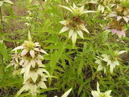
While still at the Zarahemla Temple site, children of all ages, parents and other adults gathered Spotted Bee Balm flowers. This wonderful plant was discovered by Kevin Price to have great medicinal properties. They are growing in abundance on a berm (long, narrow mound of earth) on the Zarahemla Temple site one mile from the Mississippi River. Amazingly this plant loves sandy soil and was discovered growing precisely on this 14-acre site. It is a mystery to many.  How could sand be in a place that was a mile from the Mississippi River?  Who put the sand there so it could grow?  I can’t imagine early farmers dragging wagon loads of sand.  More research will be done these next few weeks to see exactly how medicinal these special plants are and how our modern society can use the oil to keep ourselves healthy.  Stay tuned.

There is so much in the earth to discover and the blessings of the Book of Mormon written by faithful, powerful men along with their faithful women who lived so long ago, leave us their testimony of their experiences and faith.  They leave behind a great legacy of truth. The Book of Mormon just came to life for many in Montrose that day.


Thursday, July 23, 2020

What do Brigham Young’s Spyglass and the City of Zarahemla have in Common?

For the quick answer: “they both were lost”.
Replica of Brigham Young Spyglass

For the explained long answer: According to the ChurchHistory section of churchofjesuschrist.org, Brigham Young used a collapsible brass and leather spyglass which was popular in that day.  On President Young’s first trip to the Salt Lake Valley in 1847, he used this spyglass to scout the trails ahead, search for game and watch for danger. In May of 1847, while the Pioneer Saints were still on the plains of central Nebraska some of their cows wandered away getting too near a buffalo herd.

From the Church History Website: “Concerned that the cows would run away with the herd, Brigham Young, Heber C. Kimball, and Thomas Woolsey chased after them. They were able to turn the cows back, but Brigham lost his spyglass in the confusion. The three men made a careful search but could not find it.”

Company member Thomas Bullock reported that on the next day they encountered thousands and thousands of Buffalo . . .”marching directly in our path going the same way as the Camp. There were such a mass of living blackness that the Van Guard could not see the Prairie beyond them.
Knowing that Brigham Young was upset about the loss of his spyglass, Porter Rockwell and several others returned to search for it. William Clayton recorded, ‘About four p.m., Porter and the others returned, having found the spy glass which was a source of joy to all the brethren.’ Miraculously, the spyglass was intact and undamaged, despite the thousands of buffalo that could have trampled it.” Quite the miracle.

On the other hand, Zarahemla was destroyed by fire, as written in 3 Nephi chapter 8, later rebuilt and then lost. In the last five years, the Heartland Research Group has made great strides in recovering what looks like to be the Zarahemla Temple grounds and the City of Zarahemla itself located in Montrose, Iowa. This is truly a miracle as no one ever thought anyone would ever find Zarahemla just like Brigham Young never thought he would ever find his spyglass after that herd of buffalo trampled their way through Nebraska. The best explanation of the Zarahemla Temple found is in this video: https://www.youtube.com/watch?v=sNqmJw-GBds

Miracles do happen when we are on the Lord’s errand. We are inspired to never give up and do our best. Our testimonies are strengthened of a loving, kind Heavenly Father and for the restored Gospel of Jesus Christ.

More Mississippi Crossings in Early Church History


For the next two weeks, the Heartland Research Group will be gearing up for their great expedition to find the crossing of the River Sidon where Alma and Amlici fought each other alongside their armies. The Amlicites together with the Lamanites wanted to make war on the Nephites headed up by Alma.  This great story from Alma Chapter 2 in the Book of Mormon talks about the armies crossing the River Sidon to fight until one side won. From my prior post of Crossing the River Sidon, we learn that the Mississippi River is the River Sidon. Since Nauvoo sits on the banks of the Mississippi River, there were several other crossings of this river by early members of The Church of Jesus Christ of Latter day Saints before the Saints left Nauvoo in 1847. Learning of these crossings adds interest to the Heartland Research Group search for the earlier crossing in 90 B.C. What is exciting to many is the understanding of where the great city of Zarahemla is located according to Joseph Smith’s revelation in the Doctrine and Covenants (Section 125 verse 3) and to those researching the Montrose, Iowa area within the Heartland Research Group.

Joseph Smith and Joe Duncan
To understand the whole story of one early crossing of the Mississippi, we must understand some of the difficulties Joseph Smith had during the time living in Nauvoo with his wife, Emma and their children. He was falsely accused many times of crimes he never committed and this particular time was no different. Taken from Rod Meldrum’s book.” Exploring the Book of Mormon in America’s Heartland, we learnOn August 8, 1842, a Warrant was served by Governor Carlin for the arrest of Joseph Smith and Porter Rockwell who had been charged with the near fatal shooting of Gov. Lilburn Boggs. Joseph and Porter went into hiding, knowing their innocence and that this was just another attempt to thwart the work of the Lord.”

Another interesting element is the story of Joseph Smith’s horse that was given to him by Moses Martin.  Moses Martin came from a wealthy family in Tennessee. Moses and his wife, Amanda, were converted to the Gospel of Jesus Christ and helped settle Nauvoo. He also owned a beautiful horse but as the story goes; this beautiful horse was spirited and unruly so much so that Amanda was afraid to take care of him when Moses went away.  One day, Joseph Smith approached Moses and said to him, “Brother Sanders, give the horse to me and I’ll promise that you will never lose by it.”  Moses Martin replied, “I would, but I am afraid that he may hurt you.”  Then the Prophet said, “No, he would never hurt me.”  So Moses tossed him the rope and said, “His is yours!” (https://www.josephsmithjr.org/joe-duncan-joseph-smiths-horse/)

Joseph named the horse Joe Duncan after the unsupportive former Governor of Illinois and the horse never did hurt Joseph. It was widely known that Joseph traveled everywhere on that horse, so what happened next was interesting.

On August 11 of 1842, Joseph left Nauvoo and spent a little time with his Uncle John Smith's in Zarahemla. The reference to Zarahemla is again taken from the Doctrine and Covenants and in August of 1841 became a stake of Zion in Iowa. (It was discontinued in January of 1842) Joseph’s Uncle lived there and he went to visit him crossing the river from Nauvoo. The story continues: “On the night of Thursday, the 11th of August in 1842, he left in a skiff with Brother Erastus H. Derby to an island on the Mississippi between Nauvoo and Montrose where they were met by Emma, Hyrum, William Law, Newel K. Whitney, George Miller, William Clayton and Dimick B. Huntington.

Joseph’s visitors stated to him the current report that the Governor of Iowa had issued a warrant for his apprehension and that the sheriff of Lee County was expected any hour to execute it.  The situation was critical and Joseph’s immediate removal from his Uncle John’s seemed necessary. It was decided that the Prophet should proceed to the house of Edward Sayers in Nauvoo and abide there for a time.  The next day William Walker crossed the river from Nauvoo into Iowa, riding the Prophet’s well known horse Joe Duncan, to lead the gathered officers and kidnappers away from the area that Joseph was on the Nauvoo side of the river.

“This stratagem was conceived to trick the Sheriff and his Deputies.  From Dean C. Jesse’s The Papers of Joseph Smith, in the Illinois journal states,” Accordingly Joseph’s new horse which he rides was got ready and Wm. Walker proceeded to cross the river in sight of a number of persons.
 The next day, “A report came over the river that there were several small companies of men in Montrose, Nashville, Keokuk, etc., in search of Joseph. They saw his horse go down the river yesterday and were confident he was on that side.” The Mississippi River was shallow enough on this late summer day to ride a horse across it at this location.” Exploring the Book of Mormon in America’s Heartland by Rod Meldrum pg 80-81

Imagine the Mississippi River being shallow enough to cross by horse!  Imagine two armies of people fighting like dragons as they cross this river.  It happened so long ago and the story continues as the Heartland Research Group explores the Mississippi River in Montrose Iowa during the first week of August.  Stay tuned.


Chief Keokuk: Link to the Past


By Valerie Steimle with John Lefgren

During the 1830 census, it was established that 105,060 Indians were living on tribal lands, east of the Mississippi River. Keokuk, Chief of the Sauk Tribe was one of those Indians. In that same year, Andrew Jackson signed the Indian Removal Act which authorized the President of the United States to make treaties with the Indians to exchange lands east of the Mississippi River for lands west of that river. Because of this treaty, 100,000 Native American’s were relocated to the west.
Picture taken by SM Baer.  Used by permission
Soon after the signing of the 1830 Removal Law, Keokuk understood that the Indians had no chance of winning any battle against the white settlers. Knowing this, he determined that it would be better for his people to negotiate with the Federal Government rather than go to war.
Chief Keokuk was a master at negotiations and knew he could get the best terms in exchange for his people’s eastern lands. He negotiated annual payments in gold and silver for the lands which made him popular with not only his own people but with the white settlers who didn’t have to fight with the Indians.

Chief Keokuk moved his tribes several times and always acted as an ardent friend of the Americans, visiting Washington, Philadelphia and Boston. He was a great orator and was very conscious of his public image. Some of the leading artists of that day painted Keokuk as a model of a good Indian Chief. One such painting was a mural in the LDS Mesa Temple wall where the stairs lead to the second floor. The story behind the mural is an interesting one:

In August 1841 Keokuk and 100 other chiefs camped for several days across the river from Nauvoo.  A few years before, Keokuk had briefly met Joseph Smith when he received a copy of the Book of Mormon. During the first week of August representatives from The Church of Jesus Christ of Latter day Saints crossed over to Iowa to meet Keokuk. They made detailed arrangements for a social event for Keokuk and more than 100 fellow Chiefs together with their wives, to meet Joseph Smith and his people in Nauvoo.

The Indians and the members of the Latter day Saints agreed on the details for an all-day event that was to be a summer festival of diplomacy including food, music, and dance. The Indians would bring their drums and the Church members their brass band. The arrangements were clear and agreeable to both sides. On the appointed morning of Thursday, August 12th, the Ferryman took two flatboats and one ferry over the river from Nauvoo to Montrose to get the Indian guests whose total number was greater than 200. Joseph had pre-arranged for the city's brass band and a military unit to greet the arrival of this large group of Indians. These guests were at the time some of the most significant leaders of Native Americans in the country. Keokuk had a great sense of drama and after he and his people came to the Nauvoo landing they remained on the ferry and flatboats.

Keokuk asked where was the leader of the Mormon Church. (as was called back in that day) The welcoming committee said that Joseph Smith was waiting for them up the road in the grove. Keokuk said that he would not get off the ferry except that Joseph Smith was there to greet him in person. A messenger immediately went to get the Prophet and after a short time, Joseph and Hyrum came down to the landing to welcome Keokuk and his fellow Chiefs and their wives to Nauvoo.

For the rest of that day, there was a summer celebration in the grove. Church members offered the visitors their best "dainties" and fresh melons along with their brass band and singing. The Indians entertained the Church members with their drums and dancing. This was a very significant event for both the LDS Church members and the Indians. For Joseph Smith, this was one of the most important social events of his life. He made a speech to as many as 500 people when he announced that God had revealed to him that the Book of Mormon was an account of the fathers of Keokuk and his fellow Indian chiefs. Joseph Smith declared this as a direct revelation from God and thereby confirmed the truth of the Book of Mormon that it was "written to the Lamanites, who are a remnant of the house of Israel." The giving of his testimony to those Native Americans was very important for Joseph Smith. Keokuk was the living embodiment of the people of the Book of Mormon.

An account of the day's activities was placed in the documentary history of the Church. The children of some of those members who were there would be so influenced by the telling of Keokuk's visit to Nauvoo that when the Mesa Temple was built in the 1920s, an artist created the mural that was used on the wall with the stairs to depict the day of Thursday, August 12th, 1841, when Chief Keokuk and his fellow Chiefs came to visit Joseph Smith.

Tuesday, July 7, 2020

Chief Keokuk: A Link to the Past


By Valerie Steimle with John Lefgren

Photo by SM Baer Parker/ Used by permission

During the 1830 census, it was established that 105,060 Indians were living on tribal lands, east of the Mississippi River. Keokuk, Chief of the Sauk Tribe was one of those Indians. In that same year, Andrew Jackson signed the Indian Removal Act which authorized the President of the United States to make treaties with the Indians to exchange lands east of the Mississippi River for lands west of that river. Because of this treaty, 100,000 Native American’s were relocated to the west.

Soon after the signing of the 1830 Removal Law, Keokuk understood that the Indians had no chance of winning any battle against the white settlers. Knowing this, he determined that it would be better for his people to negotiate with the Federal Government rather than go to war.

Chief Keokuk was a master at negotiations and knew he could get the best terms in exchange for his people’s eastern lands. He negotiated annual payments in gold and silver for the lands which made him popular with not only his own people but with the white settlers who didn’t have to fight with the Indians.

Chief Keokuk moved his tribes several times and always acted as an ardent friend of the Americans, visiting Washington, Philadelphia and Boston. He was a great orator and was very conscious of his public image. Some of the leading artists of that day painted Keokuk as a model of a good Indian Chief. One such painting was a mural in the LDS Mesa Temple wall where the stairs lead to the second floor. The story behind the mural is an interesting one:

In August 1841 Keokuk and 100 other chiefs camped for several days across the river from Nauvoo.  A few years before, Keokuk had briefly met Joseph Smith when he received a copy of the Book of Mormon. During the first week of August representatives from The Church of Jesus Christ of Latter day Saints crossed over to Iowa to meet Keokuk. They made detailed arrangements for a social event for Keokuk and more than 100 fellow Chiefs together with their wives, to meet Joseph Smith and his people in Nauvoo.

The Indians and the members of the Latter day Saints agreed on the details for an all-day event that was to be a summer festival of diplomacy including food, music, and dance. The Indians would bring their drums and the Church members their brass band. The arrangements were clear and agreeable to both sides. On the appointed morning of Thursday, August 12th, the Ferryman took two flatboats and one ferry over the river from Nauvoo to Montrose to get the Indian guests whose total number was greater than 200. Joseph had pre-arranged for the city's brass band and a military unit to greet the arrival of this large group of Indians. These guests were at the time some of the most significant leaders of Native Americans in the country. Keokuk had a great sense of drama and after he and his people came to the Nauvoo landing they remained on the ferry and flatboats.

Keokuk asked where was the leader of the Mormon Church. (as was called back in that day) The welcoming committee said that Joseph Smith was waiting for them up the road in the grove. Keokuk said that he would not get off the ferry except that Joseph Smith was there to greet him in person. A messenger immediately went to get the Prophet and after a short time, Joseph and Hyrum came down to the landing to welcome Keokuk and his fellow Chiefs and their wives to Nauvoo.

For the rest of that day, there was a summer celebration in the grove. Church members offered the visitors their best "dainties" and fresh melons along with their brass band and singing. The Indians entertained the Church members with their drums and dancing. This was a very significant event for both the LDS Church members and the Indians. For Joseph Smith, this was one of the most important social events of his life. He made a speech to as many as 500 people when he announced that God had revealed to him that the Book of Mormon was an account of the fathers of Keokuk and his fellow Indian chiefs. Joseph Smith declared this as a direct revelation from God and thereby confirmed the truth of the Book of Mormon that it was "written to the Lamanites, who are a remnant of the house of Israel." The giving of his testimony to those Native Americans was very important for Joseph Smith. Keokuk was the living embodiment of the people of the Book of Mormon.

An account of the day's activities was placed in the documentary history of the Church. The children of some of those members who were there would be so influenced by the telling of Keokuk's visit to Nauvoo that when the Mesa Temple was built in the 1920s, an artist created the mural that was used on the wall with the stairs to depict the day of Thursday, August 12th, 1841, when Chief Keokuk and his fellow Chiefs came to visit Joseph Smith.


Monday, July 6, 2020

Clues to the Crossing


As discussed in my last post, our August event near Nauvoo, Illinois will include finding the crossing of Alma and his army as recorded in Alma chapter 2.
In order for the search of this crossing to be successful, there are certain elements that must be studied to understand where this spot exists. The first clue is the Robert E. Lee survey.

Traveling up and down the Mississippi River was pretty common by the early 1800’s but crossing it was a bit dangerous. There is a place along this river called the Des Moines Rapids that lies between Nauvoo, Illinois and Keokuk, Iowa. The Des Moines Rapids limited steamboat passage because of the “dangerous, sharp, rocky bottom” as noted by Swedish novelist, Fredrika Bremer, who in 1850, was taking a trip down the Mississippi from St. Paul.   Gate City Newspaper

In 1937, a group of Army Corps of Engineers led by Robert E. Lee (the same Robert E. Lee who was the confederate general in the War Between the States) was a cartographer which most people did not know. Robert E. Lee and his group took a survey intending to cut a channel through the rapids, but after three months of trying along with budget cuts, the project was canceled. Nauvoo The Beautiful

The Army Corps of Engineers did another survey of the same Des Moines rapids in 1866, just after the War Between the States.  This time Lieutenant Colonel James H. Wilson was in charge of  making this survey. Colonel Wilson's survey was even more extensive than Lee's with more information.

 The Heartland Research Group realized Robert E. Lee’s original survey matched up with the description in the Book of Mormon of the River Sidon that helped pin point an approximate location from over a 2,000 mile distance of the river down to a few acres. Lee’s survey marks the point on a chart that shows where the flow of the river's water at harvest time would have been sufficiently low so as to allow an ancient army to cross the large river.

The second clue to the whereabouts of this crossing has to do with the river’s first and biggest dam built in Keokuk, Iowa in 1913. The town of Keokuk was named after the famed chief of the Sauk tribe who met with Joseph Smith back in 1841 in Nauvoo but that is a story for another time.

What is interesting about the dam in Keokuk, is that all water flowing down the river has to pass through the dam each day and there is no water being stored as in other hydro power projects. That’s a lot of water passing through so it could be that all the evidence of that army crossing was washed away. Reportedly, the Keokuk Dam pond is filling with sediment due to slowing of the river in that area which would make searching for Alma’s army crossing location more difficult because if may be covered in sediment. The more we study this area, the more difficult the finding of this location sounds.

In the late 19th century, the U.S. Army Corps of Engineers employed as many as 1,000 workers to build the Des Moines Rapids Canal near the dam. In that project, they blasted as much as a million tons of limestone rock on the west bank. The obvious question is what will be the effects of this blasting on finding the immediate area that is associated with the Battle of Zarahemla.

Another clue we need to study is the trail of the Mississippi River. The Des Moines River flows into the Mississippi River just below Keokuk, Iowa.  For approximately 25 miles before this river reaches the Mississippi River, it had served as a state boundary line between Iowa and Missouri. If we looked at a map from early 1800, we would see the meandering of the river trail. But now this boundary does not follow the current Des Moines river channel because it has migrated from its early 1800s path, albeit a few hundred feet in one way or the other. In some places it is the same with the Mississippi River. Over the years it has changed its course somewhat through meandering which increases the challenge to those searching for the crossing place of the Nephite and Amalicite armies. With the study of the river, we have found however, that the geologic structure of the Des Moines Rapids area has restricted channel meandering.

With these clues and many others put together by historians, engineers and scientists, we believe we will be successful in finding the crossing that will lead to even more clues to the city of Zarahemla’s location.


Crossing the River Sidon

In our search for physical evidences of the Book of Mormon lands in the United States, we need to start with Zarahemla and the River Sidon.  From the 600 BC to 400AD, the Book of Mormon lands were described in the book itself.  Zarahemla was the largest city in the area and according to https://zarahemla.site/that-great-citythe most frequently mentioned place by name in the Book of Mormon.”

The U.S. Geological Survey tells us that the Mississippi River is one of the world’s largest river systems.  It is made up of several large tributaries making it the largest river and river system in North America.  It flows 2,340 miles from its source at Lake Itasca through the midcontinent of the United States all the way to the Gulf of Mexico passing by New Orleans.

From the National Park Service River Facts the name "Mississippi" comes from the Anishinabe people (Ojibwe Indians.) They called the river "Messipi" or "Mee-zee-see-bee," which means "Big River" or "Father of Waters." Dakota Indians called the river "Hahawakpa," meaning "River of the Falls" in reference to the falls we now call the Falls of St. Anthony.” 
So what does the River Sidon have to do with the Mississippi River and Zarahemla?
First, we learn the word Sidon is the Greek name which means “fishery” for the ancient Phoenician port city of Sidonia which is now Lebanon.  Many Native Americans have considered this river a great resource for fish.
We read about Prophet Joseph Smith receiving a revelation from God which is written in the Doctrine and Covenants, section 125 in verse 3:
 “Let them build up a city unto my name upon the land opposite the city of Nauvoo, and let the name of Zarahemla be named upon it.”  Interestingly enough, the word Zarahemla in this verse has a cross reference to Omni 1:14 in the Book of Mormon which says:
14 “And they discovered a people, who were called the people of Zarahemla. Now, there was great rejoicing among the people of Zarahemla; and also Zarahemla did rejoice exceedingly, because the Lord had sent the people of Mosiah with the plates of brass which contained the record of the Jews.”

For years and years the Heartland theory has matched the River Sidon with the Mississippi River.  How is this possible? We read in the Book of Mormon itself that Zarahemla is close to the River Sidon. According to The Book of Mormon, the River Sidon is east of Zarahemla which lines up with what 


Joseph Smith reveled. It would make sense from a geographical point of view that the River Sidon is the Mississippi River. As more study is done, we find that there is a possibility of finding the place of the war mentioned in Alma.

From Alma chapter 2 verses 27 and 28 and verses 33 through 35, “And behold, as they were crossing the river Sidon, the Lamanites and the Amlicites, being as numerous almost, as it were, as the sands of the sea, came upon them to destroy them.
28 Nevertheless, the Nephites being strengthened by the hand of the Lord, having prayed mightily to him that he would deliver them out of the hands of their enemies, therefore the Lord did hear their cries, and did strengthen them, and the Lamanites and the Amlicites did fall before them.
33 But Alma, with his guards, contended with the guards of the king of the Lamanites until he slew and drove them back.
34 And thus he cleared the ground, or rather the bank, which was on the west of the river Sidon, throwing the bodies of the Lamanites who had been slain into the waters of Sidon, that thereby his people might have room to cross and contend with the Lamanites and the Amlicites on the west side of the river Sidon.
35 And it came to pass that when they had all crossed the river Sidon that the Lamanites and the Amlicites began to flee before them, notwithstanding they were so numerous that they could not be numbered.”
Google Earth of the Mississippi River

We know that the bodies of the Lamanites who had been slain were tossed into the waters of the River Sidon. We just have to find it.  An exciting event will be taking place during the first week of August of this year on the Mississippi River. A group of more than 15 professionals in science and engineering will be joining together to search for this spot. A 32-foot Pontoon Mississippi Riverboat named “Truth” is being outfitted for this expedition. Surveys of this land and river area are being studied.  Using SENSYS, advanced magnetometry (which measures the magnetic pull of objects under the ground) and military-trained scuba diving, we will be able to see and chart the river bottom.  Hold onto your hats as all of these preparations are taking place to find the crossing of the River Sidon.

For more information: Zarahemla.site

Discovering the Promised Land

Discovering the places we read about is very exciting. As we read descriptions and narrations of these faraway places, we visualize through site, smell, sound and feel of what they would actually be like. What would it be like to actually visit the places in the Book of Mormon we have read about for so many years?  When I visited the Sacred Grove, my testimony grew exponentially of the First Vision. When I visited Nauvoo, my love for those pioneers filled my heart to over flowing in appreciation of what they experienced and saw through their eyes and understand how they felt.  It was an amazing reality.

For those trying to understand the places of the Book of Mormon, we search that book for clues and then find evidences of where they are located. Let me start from the beginning. A letter written to John Wentworth who was the editor of the Chicago Democrat, from Joseph Smith was very instrumental in beginning to understand where the Nephites and Laminates lived.

Here an excerpt of that letter which start the clues: “I was also informed concerning the aboriginal inhabitants of this country', and shown who they were, and from whence they came; a brief sketch of their origin, progress, civilization, laws, governments, of their righteousness and iniquity, and the blessings of God being finally withdrawn from them as a people was made known unto me: I was also told where there was deposited some plates on which were engraven an abridgment of the records of the ancient prophets that had existed on this continent ...”


Joseph Smith wrote for the Times and Season Newspaper in editorials called “American Antiquities” which corroborates wars described in the Book of Mormon with archaeological finds in northern America. Josiah Priest also contributed some of this information under the approval of Joseph Smith.  His statements were as follows: "Weapons of brass have been found in many parts of America, as in the Canadas, Florida, etc., with curiously sculptured stones, all of which go to prove that this country was once peopled with civilized, industrious nations.”


In other readings, the Times and Seasons associates earth, timber and metal works found in northern American including artifacts of mount builder societies with implements and construction as described in the Book of Mormon.  It’s fascinating to put the pieces together.


In another letter written by Joseph Smith to N.C. Saxton, editor of the Rochester Observer, January 4, 1833 reprinted in the Times and Season November 15, 1844 it says:


“The Book of Mormon is a record of the forefathers of our western tribes of Indians; having been found through the ministration of an holy angel, and translated into our own language by the gift and power [of] God, after having been hid up in the earth for the last fourteen hundred years, containing the word of God which was delivered unto them. By it we learn that our western tribes of Indians are descendants from that Joseph that was sold into Egypt, and that the land [of] America is a promised land unto them, and unto it, all the tribes of Israel will come, with as many of the Gentiles as shall comply with the requisitions of the new covenant.”


What we have in our country is evidences of those early people of this continent who made covenants with God to live in this Promised Land.  Nephites and Lamanites left behind a great history here and although we cannot see some of those evidences, they are still there waiting to be discovered.


One such place was told by Joseph Smith from a vision of these areas which was written down by Wilford Woodruff, Heber C. Kimbal, George A. Smith and many others:


"On the top of the mound were stones which presented the appearance of three altars having been erected one above the other, according to the ancient order; and the remains of bones were strewn over the surface of the ground. The brethren procured a shovel and a hoe, and removing the earth to the depth of about one foot, discovered the skeleton of a man, almost entire, and between his ribs the stone point of a Lamanitish arrow, which evidently produced his death. Elder Burr Riggs retained the arrow. The contemplation of the scenery around us produced peculiar sensations in our bosoms; and subsequently the visions of the past being opened to my understanding by the Spirit of the Almighty, I discovered that the person whose skeleton was before us was a white Lamanite, a large, thick-set man, and a man of God. His name was Zelph. He was a warrior and chieftain under the great prophet Onandagus, who was known from the Hill Cumorah, or eastern sea to the Rocky mountains. The curse was taken from Zelph, or, at least, in part-one of his thigh bones was broken by a stone flung from a sling, while in battle, years before his death. He was killed in battle by the arrow found among his ribs, during the last great struggle of the Lamanites and Nephites."


That is an incredible writing and what an incredible find and message from the Prophet Joseph Smith of this great warrior. I am overwhelmed with gratitude to hear of these stories and will continue writing about the search and discover of evidences of  the Book of Mormon in the United States.


For more information see: Finding Zarahemla


Searching for the Promised Land


Over the past five years, I have been led on a journey which took me totally by surprise.  This journey strengthened my testimony of the Book of Mormon more than anything else in the world. I have read and studied this book from cover to cover countless times from 1981 to present day, and I know without a shadow of a doubt that it is another testament of Jesus Christ. What took me a step further in my testimony was the journey as to where the Book of Mormon lands are located. 
Why is this so important to know where the Book of Mormon lands are located? Why should I even waste my time?  The answer lies within the book itself.

From Nephi speaking in the book of 2 Nephi in the Book of Mormon chapter 10, verse 10 and 11 he says: “But behold, this land said God shall be a land of thine inheritance, and the Gentiles shall be blessed upon the land. And this land shall be a land of liberty unto the Gentiles and there shall be no kings upon the land who shall raise up unto the Gentiles.”

From the Brother of Jared in Ether chapter 2 verse 9 and 12 says “(9)And now we can behold the decrees of God concerning this land, that it is a land of promise…(12)Behold, this is a choice land and whatsoever nation shall posses it shall be free from bondage, and from captivity, from all other nations under heaven, if they will but serve the God of the land who is Jesus Christ who hath been manifested by the things which we have written.”

From 3rd Nephi chapter 20 verse 22 it says: “…this people will I establish in this land, unto the fulfilling of the covenant which I made with your father Jacob; and it shall be a New Jerusalem. And the powers of heaven shall be in the midst of these people; yea, even I will be in the midst of you.”
I can go on with many more prophesies and scripture about this Land of Promise. So where is it? How are we, who believe in the Book of Mormon, able to follow this command of “serve the God of the land” if we don’t even know where it is?  It’s important for us to know so we can protect it and be free from bondage and captivity.

The Heartland Research Group has spent years researching and sharing the information of the Promise Land. There are incredible amounts of physical evidence all over the United States of the early people of this country called the Hopewell people and how they were the decedents of Lehi and his family.  Much of it is explained very well on this website.  This is the covenant land promised by God. This is the Promised Land which we are enjoying the freedoms and prosperity and as a people we need to pay attention to what God wants us to do in His land.

Ezra Taft Benson once said, “The promises of security, prosperity and freedom are directly connected to the chosen land by divine decree and secured by worship and faith in Jesus Christ.” We are those people who will secure the land by worship and faith in Jesus Christ.

The path I am following has deepened my love for the Book of Mormon and love for the United States as well. I’ll be following along this path of the Book of Mormon lands in Iowa, Ohio, Clay County, Missouri and more and I invite you to come along with me. I add my testimony to the many who know the same as Joseph Smith.  That “The Book of Mormon is the most correct of any book on this earth, and the keystone of our (The Church of Jesus Christ of Latter day Church) religion, and a man would get nearer to God by abiding by its precepts, than any other book.”  Not only do I have a testimony of the spiritual significance in our lives of the Book of Mormon but also the physical significance of the places of the The Book of Mormon in this promised land of the United States of America.


For more information see: Finding Zarahemla